Acronyms: ATIS, ILS, TAWS, TCAS, TDZE… Aviation is so rife with them, you need a 50-page cheat sheet to keep up. Now, you can add another one to the list – EFVS. This is one you’ll want to become familiar with, it could save your life!
Enhanced Flight Vision System
EFVS is the acronym for Enhanced Flight Vision System. Simply put, it’s a flight system that uses different image and sensing technologies, like high-definition video, forward-looking infrared (both Near IR and Long-Wave IR), millimeter wave radar, and low-light image intensification. EFVS combines the information from those sensors and cameras via an onboard computer into one optimized image, then provides it to the pilot in a few different ways, such as a traditional Head-Up Display (HUD), Head-Wearable Display (HWD), or Helmet-Mounted Display (HMD). All of these options offer pilots a much better image of what’s actually outside of their cockpit window than what they can see with “natural vision” in degraded visual environments and adverse weather conditions, day or night (as shown in the image below).
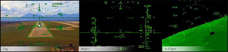
Head-Up Avionics
EFVS solutions overlay images with important, need-to-know information, such as flight symbology that provides pilots with the aircraft’s attitude, altitude, airspeed, heading, groundspeed, and radio altimeter altitude. Unlike in the past, pilots can now fly in degraded visual environments and adverse weather conditions, day or night, looking almost exclusively outside the cockpit window. After all, that’s where the terrain, obstacles, airports, and runways actually are.
UA ClearVision™ Symbology
When you add a Synthetic Vision System (SVS) that includes terrain, obstacles, and worldwide airport and runway databases to the mix, you have another acronym to remember: CVS or Combined Vision System. When using UA’s ClearVision™ EFVS with SkyLens™ HWD, the CVS’s SVS terrain and obstacles databases also offer pilots a 180° left or right synthetic 3D image of where they are flying. The system actually allows pilots to see through the aircraft airframe to the outside world, as if it were invisible, and gives them a synthetic image of what’s around them. The databases provide pilots with an SVS image of nearby terrain, and also symbology for obstacles like buildings, towers, antennas, telephone lines, and power lines, long before they would see them with their natural vision. This combined enhancement results in a much safer way to fly.
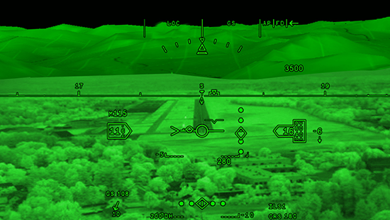
CVS Display - SVS on top, EVS on bottom
(Yellow lines & labels added for effect and do not show up on the actual system)
Unfortunately, the traditional HUD remains in a fixed forward position and cannot give pilots that 180° synthetic image situational awareness. It also means a pilot has to make sure they are seated in the correct position to fully utilize what the HUD is providing. The SkyLens HWD and SkyVis™/SkyVis Night Vision Goggle (NVG) HMD do away with that limitation. The good news is, because the Enhanced Vision System (EVS) cameras and sensors are in that fixed forward position, pilots have an amazing picture of what’s actually in front of them, allowing them to safely fly to touchdown and rollout in near zero visibility.
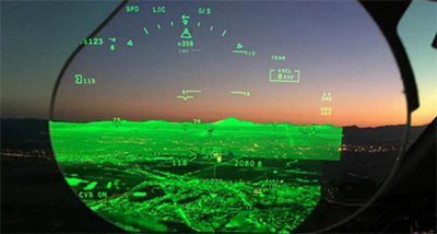
Traditional HUD EFVS image at dawn/dusk
Full Landing Procedures with No Natural Vision
You might ask, “why use EFVS?” Maybe a better question is, “how low can you go without it?” If you’re Visual Flight Rules (VFR), you can see all the way to the ground. Visibility for landing is not a problem and you can fly as low as you need. What if you’re flying Instrument Flight Rules (IFR) though? Without an EFVS, pilots flying an Instrument Approach Procedure (IAP) are restricted to their Minimum Descent Altitude (MDA) and Missed Approach Point (MAP) on a non-precision approach, or Decision Altitude (DA)/Decision Height (DH) on a precision approach. When at MDA and MAP, or DA/DH, if you do not have the requirements to operate below those altitudes, you must execute a missed approach. You either try it again, try a different IAP, or head to your alternate airport. Hopefully, visibility there is not as bad, and you successfully land.
What if you have an EFVS installed though? Federal Aviation Regulation (FAR) 91.176 allows qualified and current pilots of an EFVS equipped aircraft to descend below MDA at the MAP, or DA/DH, to 100 feet above the TouchDown Zone Elevation (TDZE) on a straight in approach, providing the visibility with the EFVS is not less than that required for the IAP being flown. To descend below 100 feet to touchdown and rollout, a pilot simply has to meet the same requirements for landing as during an IAP, visually acquire the approach lighting system, visually ID the runway threshold via markings or lights, visually ID the touchdown zone via markings or lights, etc. That is much easier since EFVS equipped pilots typically “see” from four to ten times further away than with their natural vision.
In July 2018, the Federal Aviation Administration (FAA) evaluated the Gulfstream G500 with an EFVS. After testing and evaluation, the FAA certified the G500 with that EFVS down to landing and rollout on an IAP with only 1,000 feet (300 meters) Runway Visual Range (RVR). With continued testing to lower visibilities, that RVR may eventually be reduced even further. You see, the answer really is “how low can you go without EFVS?”
Acronyms! How many were used in this article alone? I counted them and trust me, you don’t want to know. That being said, hopefully you can see (pun intended) that enhancing a pilot’s vision and improving their situational awareness can dramatically reduce the likelihood of accidents, runway related incidents, and Controlled Flight Into Terrain (CFIT), all while allowing pilots to safely fly to and land at airports in visibility limited by not only inclement weather, but smog, smoke, haze, fog, or just ordinary darkness. Isn’t that worth adding page 51 to the acronym cheat sheet?
Paul Petrash has been in aviation since 1983. He joined Universal Avionics in June 2019 after a 5-year stint overseas, teaching United Arab Emirates military pilot cadets to fly helicopters. He is a graduate of the U.S. Army’s Helicopter Pilot course and was in one of their first classes trained in the use of NVG. After graduation, Paul was assigned to Ft. Hood, Texas and was soon made an NVG Pilot in Command and Unit Trainer. Over the next couple of years, Paul helped the unit’s Instructor Pilots expand their NVG capabilities by flying newly qualified pilots on training missions to increase their skill and proficiency levels. Paul was selected to attend the Helicopter Instructor Pilot course in 1986 and has been an Instructor Pilot ever since.
After leaving the Army, Paul spent 12 years flying Helicopter Air Ambulances (HAA) in Arizona, Nevada, and Idaho. His last HAA position was as the Training Manager for Summit Air Ambulance in Caldwell, Idaho. Paul has a wealth of helicopter flight and instructor pilot experience, with over 8,000 hours of helicopter flight time and more than 1,400 hours of NVG time, almost half of that as an NVG Instructor Pilot. Paul holds FAA Rotorcraft, Commercial, and Rotorcraft Instruments ratings, as well as Rotorcraft Certified Flight Instructor (CFI) and Rotorcraft Certified Flight Instructor – Instruments (CFII) ratings.